

The sirens came first.
Loud and jarring alarms shattered the calm across Russia’s Far East, Japan’s coastal towns, all the way up to Hawaii’s Pacific shores. Within seconds, these distant regions were united by a common threat — a violent shift deep beneath the Earth’s surface.
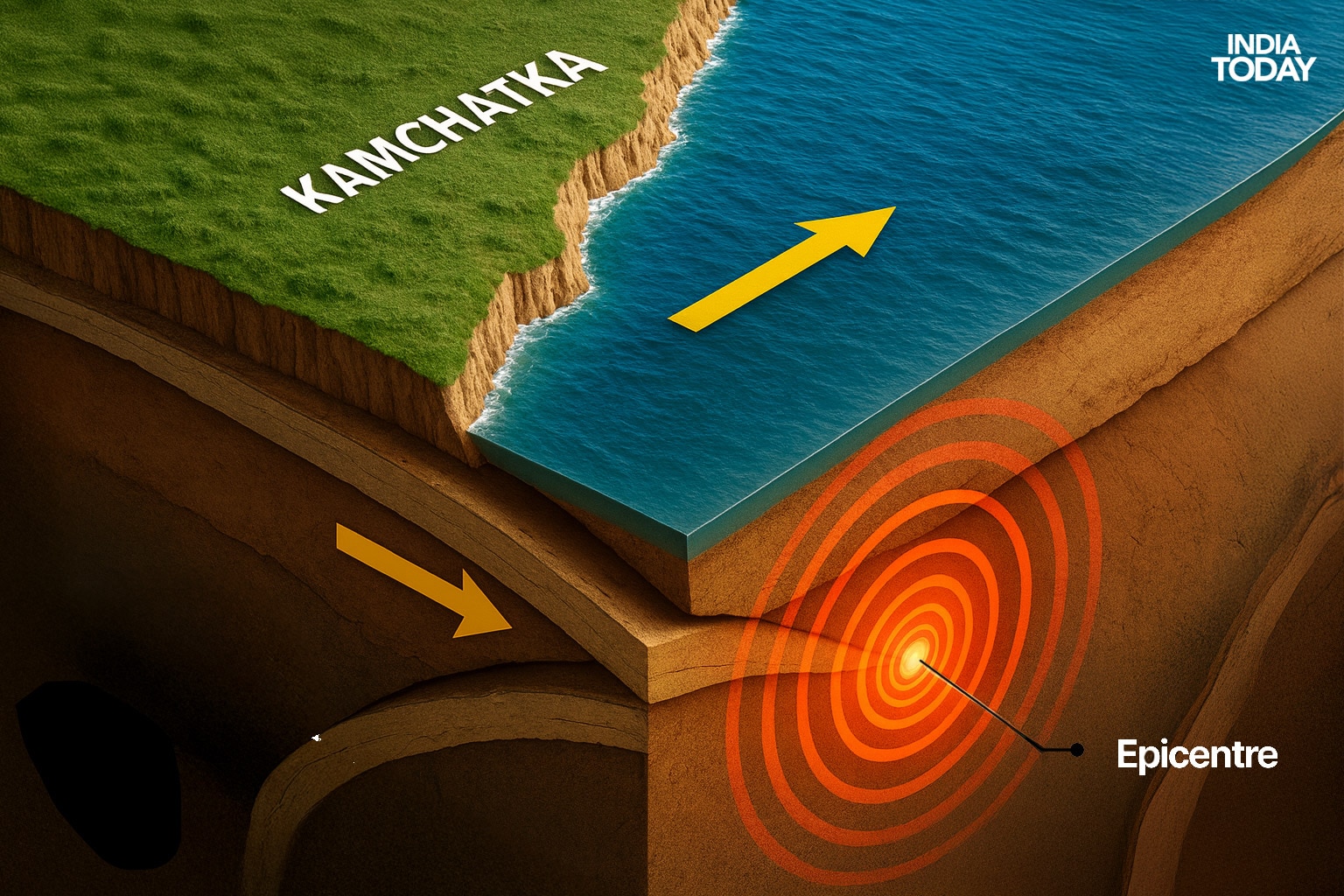
An 8.8-magnitude earthquake had erupted beneath the Kamchatka Peninsula, a remote and geologically restless landmass jutting into the Pacific. Known as one of the most volcanically active places on Earth, Kamchatka is home to more than 160 volcanoes, nearly 30 of which are still active. On this day, however, it wasn’t a volcano that stirred — it was the raw force of tectonic collision, a sudden slip along the Kuril-Kamchatka Trench, part of the volatile Ring of Fire.

A tsunami alert blares on phones across Japan. (Photo: Reuters)
KAMCHATKA MOVES
The quake was shallow, and that made it all the more dangerous. Within minutes, the shockwaves had reached the surface, damaging buildings and injuring several people in Kamchatka’s remote settlements. But the real fear wasn’t just on land. It was racing silently through the ocean.
Buoys scattered across the Pacific Ocean began to pick up subtle but unmistakable signals: water was moving — fast. Displaced by the quake’s violent thrust, waves had begun radiating outward, gaining speed and strength as they travelled. Tsunami alerts were triggered in multiple countries, including Japan, still haunted by the catastrophic 2011 tsunami, and Hawaii, where entire coastlines braced for possible impact.
In Japan, authorities ordered evacuations along the eastern seaboard. Emergency sirens howled through fishing towns and city districts alike, recalling painful memories of a disaster that had claimed nearly 20,000 lives over a decade ago. In Hawaii, similar warnings urged residents and tourists to move to higher ground, unsure of what the Pacific might deliver.
This earthquake wasn’t just a reminder of Kamchatka’s restless geology — it was a message from the deep engine of the Earth, a potent demonstration of the forces constantly shaping, bending, and sometimes breaking the planet’s crust.
It came from the infamous Ring of Fire.
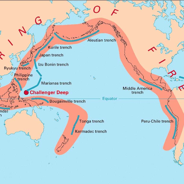
The Ring of Power that stretches across the Pacific Ocean nations. (Photo: USGS)
THE RING OF FIRE
The Ring of Fire is a vast horseshoe-shaped zone of intense seismic and volcanic activity that encircles the Pacific Ocean, stretching about 40,000 kilometers from New Zealand through Southeast Asia, Japan, the Aleutian Islands of Alaska, down the western coasts of North and South America to the southern tip of South America.
It is the most geologically active region on Earth, hosting roughly 75% of the world’s active volcanoes and about 90% of the planet’s earthquakes, including most of its largest recorded quakes.
The Ring of Fire owes its activity primarily to the movements of multiple tectonic plates bordering the Pacific Ocean, including the Pacific Plate, Nazca Plate, Cocos Plate, Juan de Fuca Plate, the Philippine Plate, and several others. Most of these boundaries are convergent plate boundaries, where one tectonic plate is forced beneath another in a process called subduction.
THE PLATES ARE ALIVE
As the oceanic plate descends, it melts due to the intense heat and pressure, generating magma that rises to form volcanoes. These subduction zones also create deep oceanic trenches adjacent to volcanic arcs, further defining the Ring of Fire’s features.
The immense pressure, friction, and deformation at these plate boundaries cause frequent earthquakes, often very powerful ones. Additionally, some parts of the Ring of Fire have transform boundaries, where plates slide past one another, accumulating stress that releases suddenly in earthquakes.
This tectonic dynamism explains why the Ring of Fire is known for producing mega earthquakes and devastating tsunamis. Large subduction earthquakes can displace huge volumes of seawater, triggering tsunamis that travel across oceans and cause widespread destruction.
Famous examples include the 2004 Indian Ocean tsunami and the 2011 Japan earthquake and tsunami, both linked to subduction zones within or adjacent to the Ring of Fire.
Sensors picks up the shockwaves from the Kamchatka earthquake. (Photo: USGS)
HOME OF THE MEGAQUAKES
The Ring of Fire has been known for unleashing some of the biggest pent-up energies outward, resulting in megaquakes.
Some of the biggest quakes include:
Valdivia Earthquake
Magnitude: 9.5
Date: May 22, 1960
Location: Near Valdivia, Southern Chile
The most powerful earthquake ever recorded struck along the Peru-Chile Trench. The Nazca Plate subducts beneath the South American Plate. It caused widespread destruction, with a death toll estimated between 1,000 and 6,000. The earthquake triggered a massive tsunami that affected Chile, Hawaii, Japan, the Philippines, and other areas. The tsunami waves reached up to 25 meters in some regions.
Alaska Earthquake a.k.a Good Friday Earthquake
Magnitude: 9.2
Date: March 27, 1964
Location: Prince William Sound, Alaska
Occurred along the Aleutian Trench, where the Pacific Plate subducts under the North American Plate. It lasted about 4.5 minutes, causing ground fissures, collapsing structures, and a tsunami that devastated coastal Alaskan towns and reached as far as California. Approximately 131 deaths were reported, mostly from the tsunami.
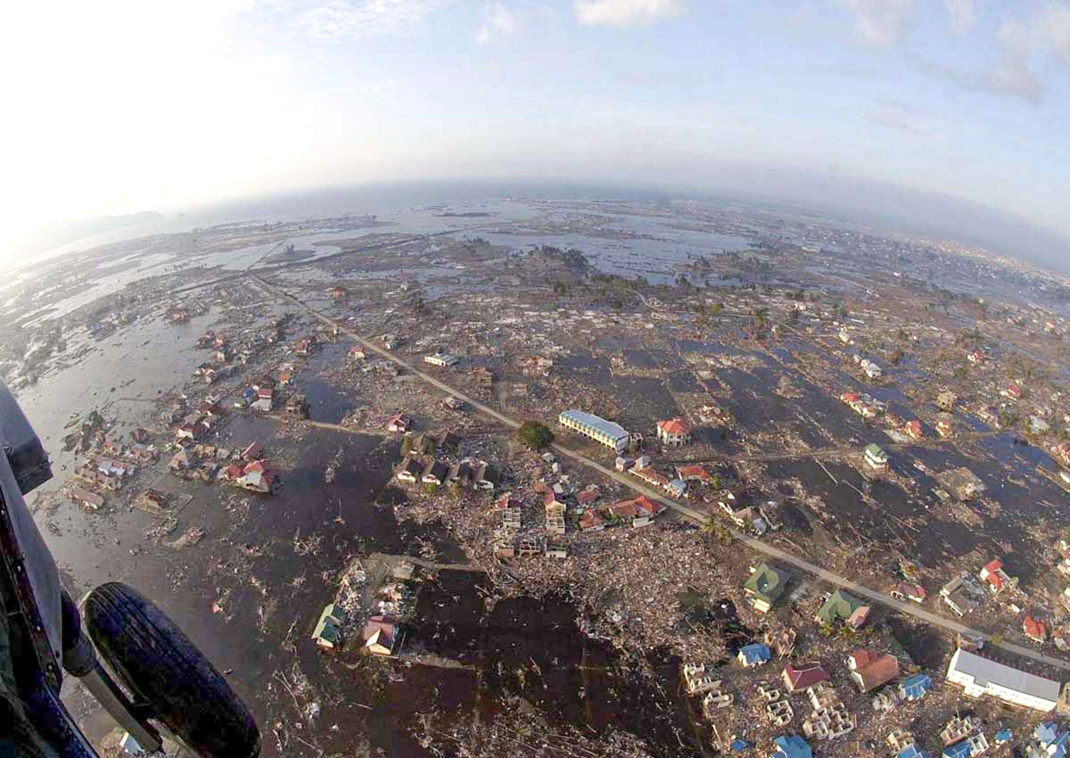
The damage from the Indian Ocean tsunami. (Photo: AFP)
Indian Ocean Earthquake
Magnitude: 9.1
Date: December 26, 2004
Location: Off the west coast of northern Sumatra, Indonesia
This earthquake occurred along the Sunda Megathrust, where the Indian Plate subducts beneath the Burma Plate. It triggered one of the deadliest tsunamis in history, killing approximately 2,30,000–2,80,000 people across 14 countries, including Indonesia, Sri Lanka, India, and Thailand. The tsunami waves reached up to 30 meters in some areas.

Tohoku Earthquake
Tohoku Earthquake
Magnitude: 9.0–9.1
Date: March 11, 2011
Location: Off the Pacific coast of Tōhoku, Japan
Occurring along the Japan Trench, where the Pacific Plate subducts under the Okhotsk Plate, this earthquake triggered a massive tsunami with waves up to 40.5 meters. It caused approximately 18,500 deaths (many missing) and led to the Fukushima Daiichi nuclear disaster due to tsunami-induced flooding. Japan is still dealing with the damages done to the nuclear plant.
Kamchatka Earthquake, Russia, Magnitude: 9.0
Magnitude: 9.0
Date: November 4, 1952
Location: Off the east coast of the Kamchatka Peninsula, Russia
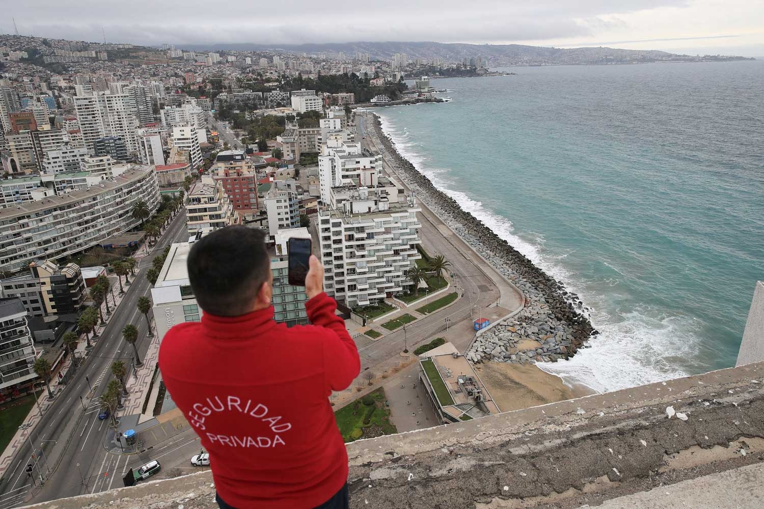
A man observing the ocean as tsunami alerts are raised after the Kamchatka earthquake. (Photo: Reuters)
This earthquake occurred along the Kuril-Kamchatka Trench, where the Pacific Plate subducts beneath the Okhotsk Plate. It generated a tsunami that affected the Kamchatka Peninsula and the Kuril Islands, with waves up to 18 meters. Limited population density resulted in fewer casualties (estimated 1,000–2,000 deaths).
The Ring of Fire remains one of Earth’s most volatile frontiers — alive, unpredictable, and pulsing with tectonic energy. It is here, in this ever-shifting arena, that nature reveals both its raw violence and its quiet authority.
As geophysicists work against time and tremors to decode the secrets buried beneath oceans and mountains, each jolt is a stark reminder: the same forces that shaped our continents and cradled our civilisations still hold the power to redraw the lines of the world we think we know.


